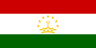
 37 Facts About Tajikistan Most People Get Wrong
Tajikistan is home to 9.9M people across 143,100 km², making it a country whose population is spread fairly evenly across its territory. It ranks 1st in the world for Mountains.
Below are 37 facts about Tajikistan, covering history, geography, economy and culture, including several that regularly surprise people who think they already know the country.
37 Facts About Tajikistan
A complete overview of Tajikistan's history, geography, economy and culture, covering everything from population and borders to language, climate and travel.
93% of Tajikistan is mountainous.
The Pamir Highway crosses the Roof of the World at over 4,600m altitude.
Tajikistan has the longest glacier outside the polar regions, Fedchenko Glacier.
Tajikistan shares a border with Afghanistan, China, Kyrgyzstan and Uzbekistan.
Tajikistan's Ismoil Somoni Peak, at 7,495 meters, is the highest point in the former Soviet Union.
The Fedchenko Glacier, 77 km long, is so large it generates its own local weather system, producing clouds and precipitation independent of surrounding conditions.
Tajik is a Persian language, making Tajikistan the only Central Asian country whose official language belongs to the Iranian family rather than Turkic.
The ancient city of Penjikent, founded in the 5th century BCE, was an important Silk Road center whose ruins contain some of the finest pre-Islamic Central Asian frescoes ever found.
The Tajik civil war (1992-1997) killed an estimated 50,000-100,000 people and produced 1.2 million refugees, one of the deadliest post-Soviet conflicts.
Sarez Lake was created in 1911 when a massive landslide dammed the Murghab River; scientists warn that if the natural dam failed, the resulting flood could kill hundreds of thousands.
Tajikistan has over 900 rivers and the world's largest concentration of glaciers outside the polar regions.
The Nurek Dam on the Vakhsh River, at 300 meters, was the tallest dam in the world for decades after its completion in 1980.
Marco Polo sheep, named by Marco Polo who encountered them in the Pamirs, are among the world's largest wild sheep and live only in the Pamir mountains of Tajikistan.
The Yagnobi people of Tajikistan's Zerafshan valley speak Yaghnobi, a direct descendant of ancient Sogdian, the lingua franca of the Silk Road.
Tajikistan is heavily dependent on remittances from migrant workers in Russia, which account for over 30% of GDP.
During the Soviet era, Tajikistan produced more than half of the USSR's entire cotton output, creating a monoculture dependency still shaping its economy.
The Murghab plateau in eastern Tajikistan is one of the most remote inhabited places in the world; communities live at 3,600 meters with virtually no services.
The Samanid dynasty, which ruled from territory including what is now Tajikistan, was the first major Persian Islamic empire and produced the medieval polymath Avicenna.
Tajikistan's Vakhsh River basin has hydropower potential that could theoretically power all of Central Asia; only a fraction has been developed.
Tajikistan has been ruled by President Emomali Rahmon since 1994, making him one of the world's longest-serving rulers outside of monarchies.
Tajik plov, a pilaf made with lamb, rice, and carrots, is considered distinct from the Uzbek version and is a point of significant cultural pride.
Istaravshan, one of the oldest continuously inhabited cities in Central Asia, was founded over 2,500 years ago and retains medieval bazaars and fortifications.
Over 50% of Tajikistan sits above 3,000 meters, making it the most mountainous country in Central Asia and one of the most mountainous in the world.
The Wakhan Corridor of Afghanistan, visible from Tajik mountain passes, creates a shared borderland where Kyrgyz herders, Wakhi farmers, and Tajik traders have coexisted for centuries.
Tajikistan exports electricity to Afghanistan in summer when rivers run high, and imports gas from Uzbekistan in winter, making energy the central axis of its regional relationships.
The Karakul meteorite crater in eastern Tajikistan, 52 km wide, is one of the largest and oldest impact craters in Central Asia, now filled by a high-altitude salt lake.
Tajikistan is located in Central Asia, Asia, with its capital city in Dushanbe.
The population of Tajikistan is approximately 9.9M, spread across 143,100 km² of territory.
Tajikistan has a population density of 69/km²: a moderate density for its region.
Tajikistan is a landlocked country with no coastline, relying entirely on neighbouring countries for access to international trade routes.
Tajikistan shares land borders with 4 countries: Uzbekistan, Kyrgyzstan, China, Afghanistan.
The official languages of Tajikistan are Tajik / Russian.
Tajikistan uses the Tajikistani Somoni (TJS) as its official currency.
Tajikistan gained independence in 1991, establishing itself as a sovereign nation in Central Asia.
The total GDP of Tajikistan is $9.3B, with a GDP per capita of $940, classifying it as a developing economy.
Tajikistan has a continental alpine, extreme cold winters climate, with the best time to visit being May–September.
Tajikistan is considered a Budget destination for travellers, with meals averaging $2–5.
Tajikistan is 93% mountains, the most mountainous country in Central Asia. The Pamir Highway, one of the world's highest roads, crosses the Pamir plateau at over 4,600m and is considered one of the greatest adventure drives on Earth.
🏆 Tajikistan World Rankings
Tajikistan holds several notable world rankings; here is how it compares globally:
Famous Places in Tajikistan
Tajikistan is home to several remarkable landmarks and destinations that draw visitors from around the world:
🏔️ Pamir Highway (M41)
One of the world's highest and most dramatic roads, crossing the Roof of the World at 4,655m
🌊 Iskanderkul Lake
A stunning turquoise mountain lake named after Alexander the Great, surrounded by 3,000m peaks
🏯 Wakhan Corridor
A remote mountain valley bordering Afghanistan and China, ancient Silk Road route with fortress ruins
🏰 Hisor Fortress
A 3,000-year-old hilltop fortress near Dushanbe, one of Central Asia's oldest settlements
Frequently Asked Questions About Tajikistan
What is Tajikistan famous for?
Tajikistan is 93% mountains, the most mountainous country in Central Asia. The Pamir Highway, one of the world's highest roads, crosses the Pamir plateau at over 4,600m and is considered one of the greatest adventure drives on Earth.
What is the capital of Tajikistan?
The capital of Tajikistan is Dushanbe.
What is the population of Tajikistan?
The population estimate for Tajikistan is approximately 9.9M.
What language do they speak in Tajikistan?
The official languages of Tajikistan are Tajik / Russian.
When did Tajikistan become an independent country?
Tajikistan gained independence in 1991.
What currency does Tajikistan use?
Tajikistan uses the Tajikistani Somoni (TJS).
What is the GDP of Tajikistan?
Tajikistan has a GDP of $9.3B, with a GDP per capita of $940.
Where is Tajikistan located?
Tajikistan is located in Central Asia, Asia.
Is Tajikistan safe to visit?
Safety conditions in Tajikistan vary by region. Always check your government's official travel advisory before visiting.
What are some fun facts about Tajikistan?
93% of Tajikistan is mountainous. The Pamir Highway crosses the Roof of the World at over 4,600m altitude. Tajikistan has the longest glacier outside the polar regions, Fedchenko Glacier.
What are some interesting facts about Tajikistan?
The Pamir Highway crosses the Roof of the World at over 4,600m altitude. Tajikistan has the longest glacier outside the polar regions, Fedchenko Glacier. Tajikistan shares a border with Afghanistan, China, Kyrgyzstan and Uzbekistan.
Tajikistan facts: what should I know?
Tajikistan is a country in Central Asia with a population of 9.9M. Its capital is Dushanbe and its official language is Tajik / Russian. 93% of Tajikistan is mountainous.
Explore More About Tajikistan
Want to explore another country? Generate a random country and discover somewhere new.